
Walk a Woodridge Street Record
A Woodridge street directory search should move from the address to the parcel, then from the parcel to named records. DuPage is the core county, though Woodridge also has Will and Cook portions. Confirm jurisdiction first. The assessment record can identify the current assessed owner and PIN. GIS can show surrounding parcels. A deed supplies transaction parties, while voter and historical directory sources add narrower evidence. No step produces a complete household list.
- Enter the full address in the correct county assessor portal and save the PIN, situs address, owner style, and legal description.
- Open the parcel in GIS, browse the same road, and capture only the parcels needed for the defined search.
- Use the sale-history document number or PIN in the Recorder search and record grantors, grantees, dates, and deed types.
- Confirm a known voter through the state or DuPage form without trying to construct a street-wide voter list.
- For past occupants, ask the library or museum about criss-cross directories, newspapers, and local files for the relevant year.
Build a Woodridge PIN
The DuPage Supervisor of Assessments portal has Address, Parcel Information, Property Owner, and Record Information modes. Its address form separates street area, number range, direction, name, type, suffix, unit, city, state, and ZIP. That matters for county-style addresses where a prefix such as 22W belongs in Street Area rather than the number box.
| Portal field | Input type | Use in a street search |
|---|---|---|
| Street Area | Text | County grid prefix when present |
| Number From / To | Number range | One parcel or a run along the road |
| Direction / Name / Type | Separate controls | Build the normalized street string |
| Unit No. / Type | Separate controls | Narrow multi-unit records |
| City / State / ZIP | Location controls | Reduce same-name street matches |
Search anonymously where available, then copy the PIN from the result. The PIN survives more changes than a street spelling and is the best handoff to maps, tax data, deeds, plats, and permits.
The official assessor screen pictured here shows the address-keyed entry point.
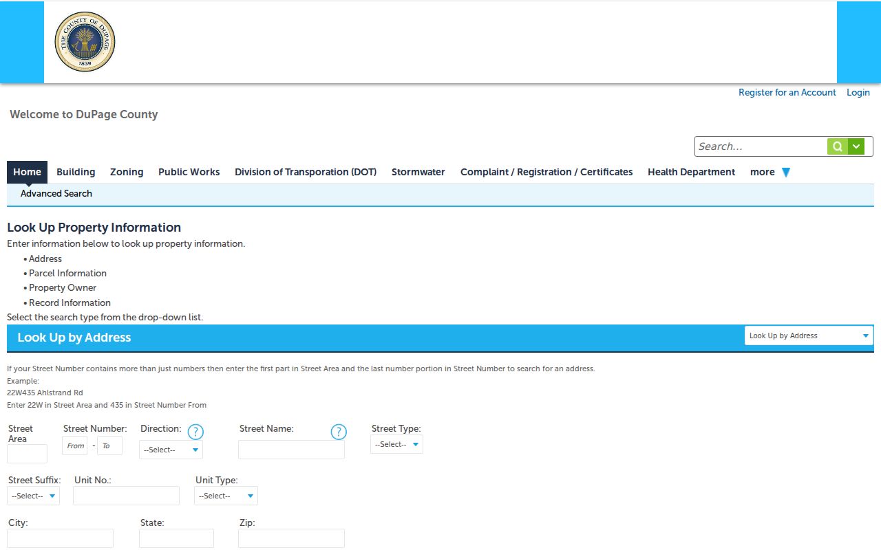
Its structured fields help prevent a false blank result caused by placing part of the address in the wrong box.
Map Woodridge Streets in GIS
DuPage GIS is the spatial part of the street directory. The parcel viewer's tabs include Searches, Shapes, Buffer, and Results. Basic and advanced searches accept PIN, Property Address, and City State ZIP. Tools include Street Intersection, map selection, measure, Pictometry, subdivision search, result pages, and Search Surrounding Area.
A parcel popup may show PIN, property address, owner, city, class, acreage, and multi-PIN fields. Result tables can add street number, direction, apartment, ZIP, land and improvement values, and legal description. GIS is an index, so verify names in the assessor or recorder record. Use a shape or buffer for a defined block, not as a reason to collect a whole neighborhood.
Woodridge Billing Versus Situs
DuPage GIS exposes separate BILL fields and PROP fields. BILLSTNUM, BILLSTNAME, BILLCITY, and related entries identify where tax correspondence goes. PROPSTNUM, PROPSTNAME, PROPCITY, and related entries identify the physical parcel, also called the situs address. They can differ because an owner receives mail elsewhere, a trust holds title, or a manager handles correspondence.
This is a useful Woodridge street directory quirk. A billing name is a lead, not proof of residence. The assessed owner also does not identify every spouse, child, renter, or other occupant. Homestead exemptions may suggest owner occupancy, but they still do not make a household roster.
Woodridge Records Found by Street
Several address-keyed sources can be chained along one Woodridge road. Each has a different keeper and meaning. The property roll identifies an assessed parcel. GIS places it beside other parcels. Deeds document land interests. Village files describe projects or cases. Election tools confirm civic geography or a supplied voter identity.
| Record Set | Keeper | What It Shows | Access |
|---|---|---|---|
| Property and tax roll | DuPage assessment and tax offices | Owner, PIN, situs, billing, sale and exemption context | Public portals and county help |
| GIS parcel map | DuPage GIS and Woodridge GIS | Parcel shape, nearby parcels, legal and map layers | Public map and service |
| Deeds and liens | DuPage Recorder | Grantors, grantees, dates, types, plats, legal descriptions | Online index, office research, copies |
| Voter confirmation | Illinois and DuPage elections | Status or precinct context for supplied information | Narrow web forms and election office |
| Permits and code files | Woodridge Community Development | Project, applicant, contractor, date, work or case context | PDFs, web intake, FOIA fallback |
The PIN connects property, tax, GIS, and deed systems. Document numbers connect sale history to recorded images. The street string is useful for permits and election geography, but it is less stable than the PIN or legal description.
Read Deeds Along Woodridge Roads
The DuPage Recorder search accepts party names, bank or trust names, subdivisions or businesses, property address, four-part PIN, document number, group, type, and date range. Name and indexed image coverage begins in 1961, PIN searching in 1985, and address searching in 1995. Office property records reach 1839.
The quickest route starts with a sale-history document number from the tax record. Open the deed, save the grantor, grantee, date, type, legal description, lot and block, then search the seller as an earlier buyer. Before the online address cutoff, leave the address field and use name, PIN, plat, book and page, or office deed books.
The Recorder form pictured here shows why the deed index is more than a surname search.
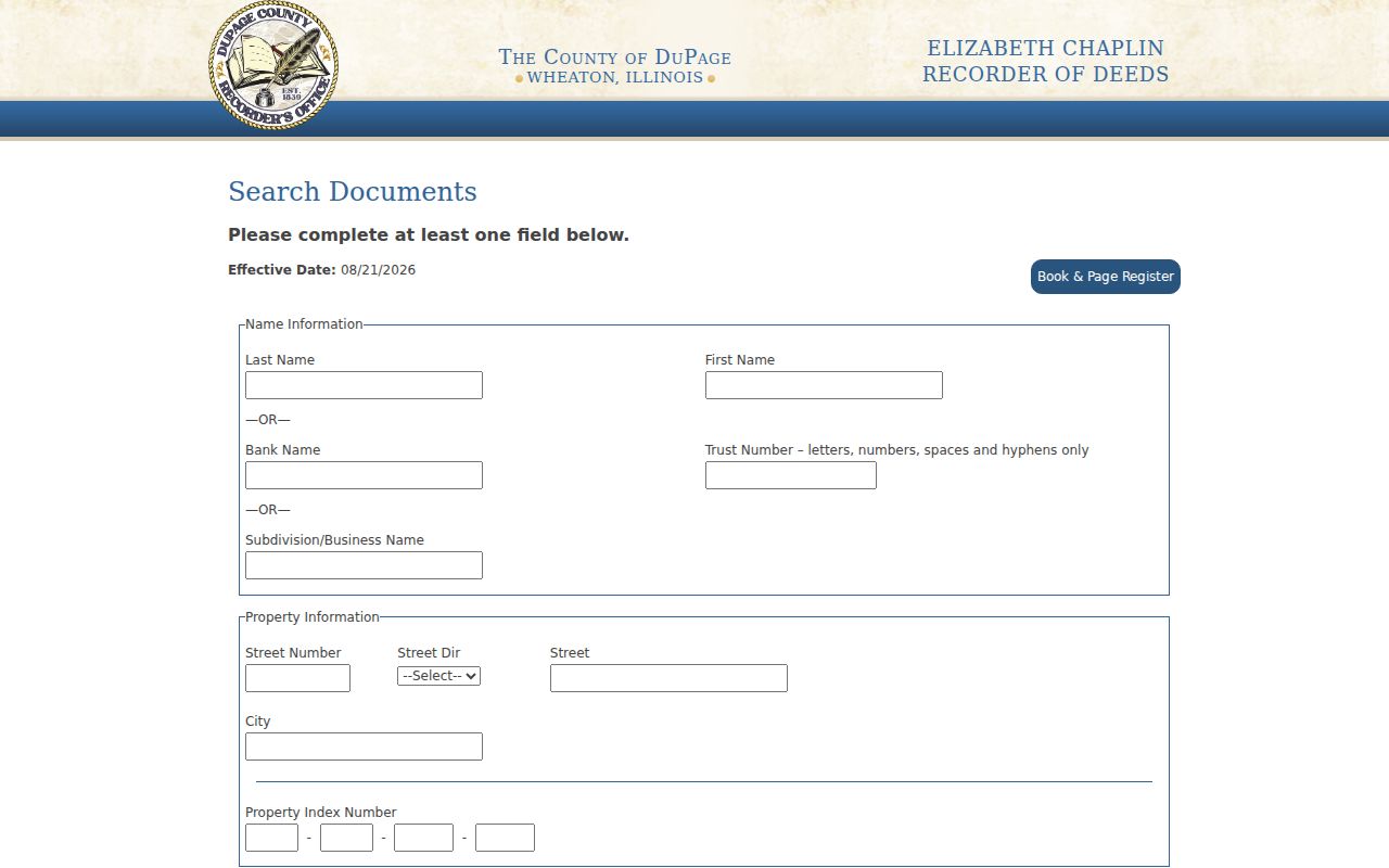
Address, PIN, party, subdivision, document, and date controls let the search adapt when a modern street string fails.
Trace Woodridge Street Permits
The Village publishes issued building permits in month and year PDF groups, including visible groups from 2017 onward and older files. Search a street name within each likely period. A permit can date a deck, roof, addition, garage, pool, solar project, remodel, or new construction and may identify the applicant, contractor, owner, work, permit date, and inspections.
Code Enforcement also accepts an address-based request for issues such as construction without a permit, abandoned vehicles, address identification, or certain containers and vehicles. An intake request is not a violation finding. Ask the Village Clerk for a narrow file through FOIA when the PDF or web page lacks the disposition. Include the address, date range, permit or case type, and desired electronic or inspection format.
Confirm Woodridge Voter Geography
The Illinois registration form asks for a known person's first and last name, birth date, ZIP, street number, and street name. DuPage's address tab asks house number, base street name, direction, suffix, and city. It can return precinct and representative context. The name tab can return registration status, sample ballot, polling place, and representatives.
Neither system offers a public list of all voters on a Woodridge street. Illinois law allows sensitive-field redaction and limits use of released voter data. A blank match may reflect an old address, spelling, status, county, or protected record. Use voter tools to confirm a person already known, not to fill gaps in a street directory.
When Woodridge Streets Changed
Woodridge grew from rural land into a planned suburb through annexations and subdivisions. Winston Hills dates to 1964, Woodridge Center annexation to 1972, Woodridge Drive development to 1974, and Wilton and Pillsbury growth to 1977. These are development milestones, not proof of a formal renumbering project. No definitive Woodridge street-renumbering year was found.
When an old address does not match, switch from the street string to the PIN, subdivision plat, lot and block, legal description, annexation instrument, or old road name. Current parcels may have been split or combined. A plat connects the present road to the land description and can show easements, common areas, vacations, and amendments.
Woodridge Reverse Directory Gaps
A criss-cross directory lists entries by street address or telephone rather than surname. It can identify a historical householder in a given publication year. Woodridge Public Library has local newspapers, genealogy databases, photos, and oral histories, but no verified complete local reverse-directory run was published in the sources reviewed.
Ask the DuPage County Historical Museum to confirm its city-directory and real-estate holdings for a specific subdivision and year. Nearby Haines directories, telephone books, atlases, and county directories may help only after their geographic coverage is checked. The 1925-26 DuPage directory sample predates Woodridge incorporation, so it cannot be presented as a modern village street directory.
- Parcel
- A mapped tract identified by a county PIN.
- Situs address
- The physical location of the assessed land.
- Plat
- A recorded map of lots, blocks, easements, and subdivision land.
- Criss-cross directory
- A historical directory arranged by address or phone.
Limits of Woodridge Street Records
A Woodridge street directory cannot reliably list every occupant. Owners may receive bills elsewhere. Renters, children, partners, and other household members may never appear in land records. Driver address data is restricted by federal law. Utility customer lists are not public resident rolls. Illinois protections can also suppress an address through the Address Confidentiality Program, election redaction, or Judicial Privacy Act.
Records should support property research, family history, an estate, civic inquiry, or a transaction check. Stop at the official access boundary. Never infer a hidden address or republish sensitive details. Confirm a deed, permit, or voter result with the office that keeps it.
Lawful use. Woodridge address records are for lawful personal research and must never be used to stalk, harass, intimidate, or harm anyone.